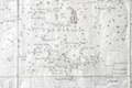
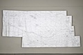
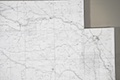
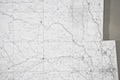
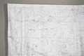
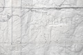
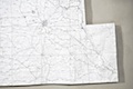
Locator Map
Locator Map and Terrain Squares, Haydon Installation (2010)

Using graphite, I hand drew Nebraska—every town, city, railroad, park, river, lake and creek—to scale (1”= 2.75mi) on 12” squares of Tyvek which I sewed together. The 95 section numbers are hand-embroidered in Braille. The completed map is 7’ (h) x 15’ (w); trapezoidal sections at each end reflect the earth’s curvature. Each square is top-stitched with a double line and the state border is top-stitched with a triple line.

Locator Map and Terrain Squares, Haydon Installation (2010) Detail, Section 35 with stamped graphic showing location of Terrain Square Detail, Sections 38-34A and 39-42A Detail, Sections 53-52A and 72-74 Detail, Sections 73A-74 and 75A-75 with state border Graphite on Tyvek; 7' x 15' (2010) Detail, Sections 2-1 and 23-25 Detail, Sections 28-26 and 49-51A Detail, Sections 12-8A,13-16A and 38-34 A Detail, Sections 12-8A; 13-16A Detail, Secs 31-29 and 46-48 Detail, Secs 31-29 and 46-48 Detail, Sections 34A-32 and 42A-45 Detail, Setions 60A-58 and 65A-67 Detail, Section 64 showing state border Detail, Secs 72-74 and 77-75

iPad Users: Please slide thumbnail content down to see more. Scroll bar does not work on iPad.